In a normal year, the Smiths Island Archaeology field school would be halfway finished at this moment. The students would be finishing up their collective work (standardized training, really) at Oven Site and dispersing into smaller teams at the other sites - Cave, Smallpox, perhaps the dock/wharf complex at Pitcher's Point. This year, however, we have suspended operations in order to catch up on database and paperwork and also for me to further develop some of my other research projects - particularly Virtual St. George's, which will feature 3D historicized reconstructions of Bermuda's first capital at various moments in the town's four-hundred-year history, developed using a videogame engine. Indeed, during a flying research visit in February, I shot more than 19,000 photographs to use in this digital reconstruction, and I supervised several students creating ArcGIS layer maps for St. George's in 1750, 1775 and 1815.
 |
| Seaward facing side of Elmina, Portuguese from 1482 to 1637 and Dutch thereafter |
 |
| Great Britain's Cape Coast Castle |
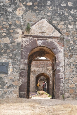
New research opportunities have also taken me beyond Bermuda in both time and space. In January, my University of Rochester colleague Renato Perucchio and I began a long-term collaboration with the University of Ghana to develop 3D models of Ghanaian Transatlantic Slave Trade castles and forts, starting with Elmina, which was built by the Portuguese in 1482. We also visited Fort Amsterdam (aka Koromantin), Fort Patience, James Fort, and Fort Usser and worked with U. Ghana Archaeology Ph.D. students to record them. The sites are enormous and challenging, both in terms of their physical size and complexity and as sites of history, shaped by clashing cultures and interests through which some Bermudians' ancestors doubtlessly passed.
All of these coastal sites also reflected a further core element of Bermudian history: shipbuilding, fishing, and boat handling, which underscores the shared African and European roots of its maritime traditions.
 |
| 3D model of Elmina, derived from UAV drone footage |
 |
Fort Amsterdam model, mid-processing
|

More recently, I completed an intensive week-long digital archaeology field project in Oplontis and Herculaneum, using a variety of digital archaeology approaches to recording and recovering eroded examples of Roman graffiti and frescoes on First Century AD sites destroyed by the eruption of Mount Vesuvius in AD 79. My U of R colleague Nick Gresens and I led a small team of three undergraduates (including Smiths Island Field School veteran Cameron Barreto) to work at Oplontis, the 95-room Villa of Poppea (Nero's wife).
 |
| photogrammetry model of Roman graffiti, appx 5 mm |
In addition to conducting photogrammetry surveys and laser scanning villa walls with a FARO focus and hand-held Artec Spider scanner, we employed a FLIR infrared thermal imaging camera and a one-of-a-kind UV cross-polarization camera recently invented at Rochester Institute of Technology (our neighbor) and thus far only used to image planets and nebulae. We are just back and starting to process the 460 GB of data we compiled.

 |
| UV imaging of an amphora's painted labl |

 |
| Active IR imaging: applying heat (via a halogen lamp) and studying the differential absorption within the wall fabric |
 |
Cameron watching the FARO scanner do its work
|
 |
Oplontis Villa A stratigraphy: the site was buried under 24 feet of volcanic ash, rock, and pyroclastic
flow (lava). Kinda makes Oven Site look easy, since we can excavate it with trowels instead of jackhammers. |


 More recently, I completed an intensive week-long digital archaeology field project in Oplontis and Herculaneum, using a variety of digital archaeology approaches to recording and recovering eroded examples of Roman graffiti and frescoes on First Century AD sites destroyed by the eruption of Mount Vesuvius in AD 79. My U of R colleague Nick Gresens and I led a small team of three undergraduates (including Smiths Island Field School veteran Cameron Barreto) to work at Oplontis, the 95-room Villa of Poppea (Nero's wife).


Comments
Post a Comment